Understanding Micronesia's Traditional Navigation and Wayfinding
The vast expanse of the Pacific Ocean, often seen as a barrier, was a highway for ancient Micronesians. Their profound understanding of the natural world allowed them to navigate thousands of miles between tiny islands, a testament to human ingenuity and an enduring cultural legacy.
The Epic Journey: A Legacy of Exploration
For millennia, the peoples of Micronesia undertook astonishing voyages across the Pacific, settling remote atolls and high islands. These journeys were not accidental drifts but deliberate, highly skilled expeditions driven by sophisticated knowledge of the environment. The ability to find land in the immense ocean was paramount for survival, trade, and cultural exchange, forging a deep connection between the islanders and their maritime world.
The Science of Wayfinding: A Holistic Approach
Micronesian navigators, known aspwoin some traditions, employed a complex, multi-sensory system of wayfinding that combined meticulous observation with generations of accumulated knowledge. It was a holistic science, where every element of nature served as a clue.
Celestial Navigation: Stars, Sun, and Moon
The night sky was the primary compass. Navigators memorized hundreds of stars and their rising and setting points on the horizon, creating a mental "star compass."
- Stars:Specific constellations guided journeys, with key stars indicating cardinal directions and latitude. The rising and setting of certain stars, such as those of the Southern Cross or the Pleiades, marked seasonal changes and provided precise headings.
- Sun:During the day, the sun's position at sunrise, midday, and sunset provided directional cues. Its changing angle throughout the day and seasons also helped estimate latitude.
- Moon:The moon, though less reliable for direction than stars, offered supplementary information, particularly concerning tides and current strength.
Reading the Ocean Swells and Waves
Perhaps the most extraordinary aspect of Micronesian navigation was the ability to "read" ocean swells. Unlike surface chop, deep-ocean swells travel thousands of miles, maintaining their direction even when other conditions change. Navigators could detect subtle changes in these swell patterns caused by distant islands.
“The Micronesian navigator does not simply look at the waves; he feels them. He lies in the bottom of his canoe, sensing the subtle movements and patterns of the ocean beneath him, using his body as a highly sensitive instrument.”
Different islands refract, reflect, or block swells, creating unique wave patterns that could indicate the presence and direction of land long before it was visible. Tools like thewapepe(stick charts) from the Marshall Islands were not maps in the Western sense but mnemonic devices used to teach and remember these complex swell patterns around islands and atolls like Ant Atoll.
Wind and Weather Patterns
Prevailing winds, squalls, and cloud formations were critical indicators. Navigators understood seasonal wind shifts (like the trade winds) and could predict weather changes by observing cloud types, their movement, and atmospheric pressure. The smell of land carried on the wind could also signal an approaching island.
Marine Life as Guides
The ocean's inhabitants provided invaluable clues:
- Birds:Seabirds, especially those that roost on land, fly out to feed in the morning and return to their nests in the evening. Observing their flight paths could lead navigators directly to an island.
- Fish:Certain fish species are associated with specific depths or types of underwater terrain, indirectly indicating proximity to land or reefs.
- Bioluminescence:The shimmering glow in the water caused by microorganisms could highlight currents or the presence of reefs.
Land Clues and Horizon Phenomena
Even before an island appeared on the horizon, its presence could be detected through indirect signs:
- Clouds:Islands often create their own weather systems, leading to distinctive cloud formations that hover over them, visible from a great distance.
- Reflected Light:The shallow waters of lagoons or coral reefs can reflect light onto the underside of clouds, creating a greenish glow known as "reef shine" or "lagoon reflection."
- Vegetation:Debris like leaves, flowers, or coconuts floating in the water can indicate the presence of nearby land, especially if they are fresh.
The Navigator's Training and Mindset
Becoming a master navigator was a lifelong commitment. Knowledge was passed down orally through generations, often within specific families, through rigorous apprenticeship. Students would spend years observing, memorizing, and practicing under the guidance of a master.
The training involved not just technical skills but also developing an acute sense of observation, memory, and intuition. Navigators had to internalize vast amounts of information and apply it dynamically in ever-changing ocean conditions. This deep connection to their environment fostered a holistic worldview, where human existence was intimately intertwined with the natural world.
In places like Yap, the cultural significance of these skills remains strong, with traditional practices and knowledge highly revered and sometimes still utilized today.
Traditional Vessels: Canoes of Discovery
The sophisticated navigation techniques were matched by equally ingenious vessel design. Micronesian voyaging canoes were marvels of engineering, built for speed, stability, and carrying capacity over long distances.
- Outrigger Canoes:Single-outrigger canoes, common across Micronesia, provided stability and efficiency. They were often asymmetrical, designed to be sailed in one direction, then shunted (the stern becoming the bow) for the return journey.
- Double-Hulled Canoes:While less common in Micronesia than in Polynesia, some larger double-hulled designs allowed for greater cargo space and stability, suitable for extensive migrations and trade.
These canoes were crafted from local materials, often breadfruit or mahogany wood, using traditional tools and methods. Their construction was a community effort, embodying the collective knowledge and spirit of the islanders.
Modern Revitalization and Cultural Significance
With the advent of Western navigation tools and increased interaction with the outside world, traditional wayfinding skills gradually declined in many areas. However, a powerful revitalization movement began in the late 20th century, notably inspired by the Polynesian Voyaging Society's Hokuleʻa and its Micronesian counterparts.
Today, efforts are underway to preserve and teach these ancient skills, not just as a historical curiosity but as a living tradition crucial to cultural identity. Master navigators, like Mau Piailug from Satawal in Yap State, played a pivotal role in teaching these methods to a new generation, ensuring the continuity of this profound heritage.
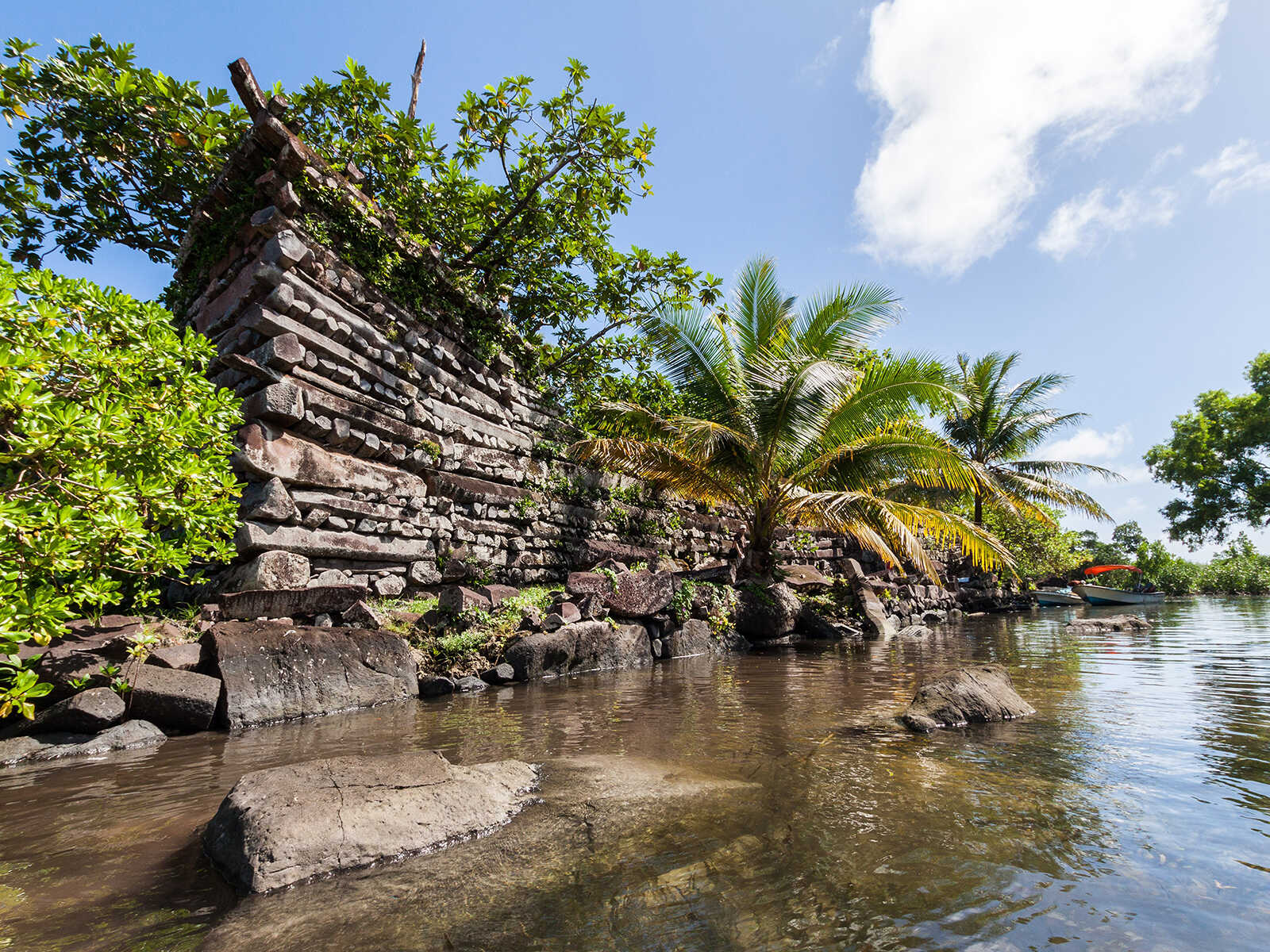
The voyaging canoes that sail today, guided by stars and swells, are powerful symbols of resilience, cultural pride, and humanity's enduring connection to the ocean. The scale of ancient achievements, such as the construction of Nan Madol on Pohnpei, speaks to the organizational and navigational prowess of early Micronesians who transported vast quantities of basalt across open water.
Experiencing Micronesia's Maritime Heritage
For visitors to Micronesia, understanding this rich navigational history adds immense depth to the travel experience. While opportunities to sail on traditional voyaging canoes are rare and often arranged through cultural organizations, you can still connect with this heritage:
- Cultural Centers and Museums:Many islands feature museums or cultural centers that display traditional canoes, navigation tools like stick charts, and exhibits detailing the history of wayfinding.
- Local Communities:Engaging with local communities, especially in more traditional islands like Yap, can offer insights into how these traditions are maintained and celebrated today.
- Natural Landscapes:Simply observing the vastness of the ocean, the flight of seabirds, or the unique cloud formations over landmarks like Sokehs Rock allows for a deeper appreciation of the natural cues that guided ancient navigators.
Micronesia's traditional navigation and wayfinding represent far more than just a means of travel. They embody a profound philosophy of living in harmony with the environment, a testament to human ingenuity, and a powerful reminder of the deep knowledge that can be gained by listening to the whispers of the wind, the rhythm of the swells, and the timeless wisdom of the stars.